
Walk Score- 07.24.07
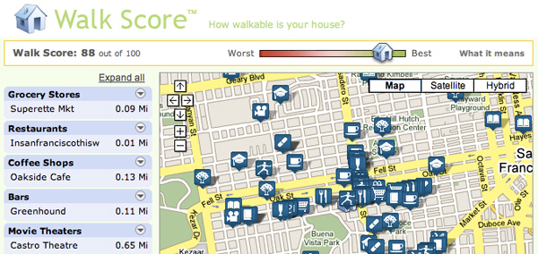
Odds are if you are reading this, you PROBABLY should check the Walk Score of your current location and get walking. I mean seriously, we spend a bit too much time at our computers… well me at least. Apparently my current walkscore is well in the green, at 88% - what is that, a B+? A-? Its been a long time since i’ve thought about grades. “70 - 90 = Very Walkable: It’s possible to get by without owning a car.”
This is an interesting mashup - Walk Score uses a patent-pending algorithm to calculate the walkability of an address based on: The distance to walkable locations near an address, calculating a score for each of these locations, combining these scores into one easy to read Walk Score. More details below on how the calculate an areas walkability…
From Walk Score:
Walkable Neighborhoods
Picture a walkable neighborhood. You lose weight each time you walk to the grocery store. You stroll home from last call without waiting for a cab. You spend less money on your car—or you don’t own a car. When you shop, you support your local economy. You talk to your neighbors.
What makes a neighborhood walkable?
Walkable communities tend to have the following characteristics:
* A center: Walkable neighborhoods have a discernable center, whether it’s a shopping district, a main street, or a public space.
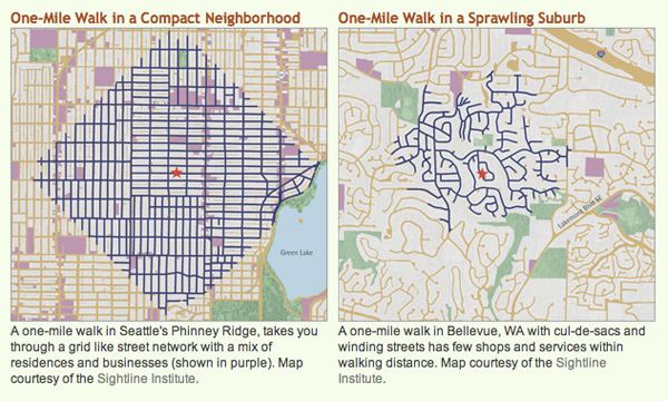
* Density: The neighborhood is compact, rather than spread out, which brings people closer to stores and jobs and makes public transportation more cost effective.
* Mixed income, mixed use: Housing is provided for everyone who works in the neighborhood: young and old, singles and families, rich and poor. Businesses and residences are located near each other.
* Parks and public space: There are plenty of public places to gather and play.
* Accessibility: The neighborhood is accessible to everyone and has wheelchair access, plenty of benches with shade, sidewalks on all streets, etc.
* Well connected, speed controlled streets: Streets form a connected grid that improves traffic by providing many routes to any destination. Streets are narrow to control speed, and shaded by trees to protect pedestrians.
* Pedestrian-centric design: Buildings are placed close to the street to cater to foot traffic, with parking lots relegated to the back.
* Close schools and workplaces: Schools and workplaces are close enough that most residents can walk from their homes.
They even have a page of “How it doesn’t work” ~ quite the work in progress, i’m inspired to get out of the apt now. (Thanks for the not so subtle hint, alex)


I believe that walk score is cool, but nowadays more and more people prefer to drive cars. Homes are often located in an area where some establishments are easier to get to by car than on foot. I’ve recently found a type of service on http://drivescore.fizber.com which is called Drive Score. It shows a map of what establishments are in your neighborhood and calculates a Drive Score based on the number of places within a convenient driving distance. It doesn’t mean that drive score is better than walk score – they are equal and both necessary in the modern world!
----- Darina 13.12.07 09:01